Sentinel-2 NDVI computation
We will use the Unix shell and curl to access the REST API. First open a shell of choice (we use bash here) and setup the login information, the IP address and the port on which the actinia service is running, so you can simply change the IP and port if your server uses a different address:
export ACTINIA_URL=https://actinia.mundialis.de/api/v3
export AUTH='-u demouser:gu3st!pa55w0rd'
# other user credentials can be provided in the same way
The following asynchronous API call computes the NDVI of the Sentinel-2 scene S2A_MSIL1C_20161206T030112_N0204_R032_T50RKR_20161206T030749:
curl ${AUTH} -X POST "${ACTINIA_URL}/sentinel2_process/ndvi/S2A_MSIL1C_20161206T030112_N0204_R032_T50RKR_20161206T030749"
The response provides the status URL that must be polled to receive the finished response:
 {
   "accept_datetime": "2018-05-30 12:25:43.987713",
   "accept_timestamp": 1527683143.9877105,
   "api_info": {
     "endpoint": "asyncephemeralsentinel2processingresource",
     "method": "POST",
     "path": "/api/v3/sentinel2_process/ndvi/S2A_MSIL1C_20161206T030112_N0204_R032_T50RKR_20161206T030749",
     "request_url": "http://actinia.mundialis.de/api/v3/sentinel2_process/ndvi/S2A_MSIL1C_20161206T030112_N0204_R032_T50RKR_20161206T030749"
   },
   "datetime": "2018-05-30 12:25:43.989044",
   "http_code": 200,
   "message": "Resource accepted",
   "process_chain_list": [],
   "process_results": {},
   "resource_id": "resource_id-6b849585-576f-40b5-a514-34a7cf1f97ce",
   "status": "accepted",
   "time_delta": 0.001340627670288086,
   "timestamp": 1527683143.989044,
   "urls": {
     "resources": [],
     "status": "http://actinia.mundialis.de/api/v3/resources/demouser/resource_id-6b849585-576f-40b5-a514-34a7cf1f97ce"
   },
   "user_id": "demouser"
 }
Poll the status of the asynchronous API call by polling the status URL. Be aware that you have to change the status url as the resource id will change for different NDVI API calls.
curl ${AUTH} -X GET "${ACTINIA_URL}/resources/demouser/resource_id-6b849585-576f-40b5-a514-34a7cf1f97ce"
The final result will contain a complete processing list as well as URL's to the resulting PNG preview image, the created NDVI GeoTiff file as well as univariate statistics of the computed NDVI scene.
 {
   "accept_datetime": "2018-05-30 12:25:43.987713",
   "accept_timestamp": 1527683143.9877105,
   "api_info": {
     "endpoint": "asyncephemeralsentinel2processingresource",
     "method": "POST",
     "path": "/api/v3/sentinel2_process/ndvi/S2A_MSIL1C_20161206T030112_N0204_R032_T50RKR_20161206T030749",
     "request_url": "http://actinia.mundialis.de/api/v3/sentinel2_process/ndvi/S2A_MSIL1C_20161206T030112_N0204_R032_T50RKR_20161206T030749"
   },
   "datetime": "2018-05-30 12:29:11.800608",
   "http_code": 200,
   "message": "Processing successfully finished",
   "process_chain_list": [
     {
       "1": {
         "flags": "g",
         "inputs": {
           "map": "ndvi"
         },
         "module": "r.univar",
         "outputs": {
           "output": {
             "name": "/actinia/workspace/temp_db/gisdbase_103a050c380e4f50b36efd3f77bd1419/.tmp/tmp7il3n0jk.univar"
           }
         }
       }
     },
     {
       "1": {
         "inputs": {
           "map": "ndvi"
         },
         "module": "d.rast"
       },
       "2": {
         "flags": "n",
         "inputs": {
           "at": "8,92,0,7",
           "raster": "ndvi"
         },
         "module": "d.legend"
       },
       "3": {
         "inputs": {
           "at": "20,4",
           "style": "line"
         },
         "module": "d.barscale"
       }
     }
   ],
   "process_log": [
     {
       "executable": "/usr/bin/wget",
       "parameter": [
         "-t5",
         "-c",
         "-q",
         "https://storage.googleapis.com/gcp-public-data-sentinel-2/tiles/50/R/KR/S2A_MSIL1C_20161206T030112_N0204_R032_T50RKR_20161206T030749.SAFE/GRANULE/L1C_T50RKR_A007608_20161206T030749/IMG_DATA/T50RKR_20161206T030112_B08.jp2"
       ],
       "return_code": 0,
       "run_time": 49.85953092575073,
       "stderr": [
         ""
       ],
       "stdout": ""
     },
     {
       "executable": "/usr/bin/wget",
       "parameter": [
         "-t5",
         "-c",
         "-q",
         "https://storage.googleapis.com/gcp-public-data-sentinel-2/tiles/50/R/KR/S2A_MSIL1C_20161206T030112_N0204_R032_T50RKR_20161206T030749.SAFE/GRANULE/L1C_T50RKR_A007608_20161206T030749/IMG_DATA/T50RKR_20161206T030112_B04.jp2"
       ],
       "return_code": 0,
       "run_time": 38.676433801651,
       "stderr": [
         ""
       ],
       "stdout": ""
     },
     {
       "executable": "/bin/mv",
       "parameter": [
         "/actinia/workspace/temp_db/gisdbase_103a050c380e4f50b36efd3f77bd1419/.tmp/S2A_MSIL1C_20161206T030112_N0204_R032_T50RKR_20161206T030749.gml",
         "/actinia/workspace/download_cache/demouser/S2A_MSIL1C_20161206T030112_N0204_R032_T50RKR_20161206T030749.gml"
       ],
       "return_code": 0,
       "run_time": 0.05118393898010254,
       "stderr": [
         ""
       ],
       "stdout": ""
     },
     {
       "executable": "/bin/mv",
       "parameter": [
         "/actinia/workspace/temp_db/gisdbase_103a050c380e4f50b36efd3f77bd1419/.tmp/T50RKR_20161206T030112_B08.jp2",
         "/actinia/workspace/download_cache/demouser/S2A_MSIL1C_20161206T030112_N0204_R032_T50RKR_20161206T030749_B08"
       ],
       "return_code": 0,
       "run_time": 0.35857558250427246,
       "stderr": [
         ""
       ],
       "stdout": ""
     },
     {
       "executable": "/bin/mv",
       "parameter": [
         "/actinia/workspace/temp_db/gisdbase_103a050c380e4f50b36efd3f77bd1419/.tmp/T50RKR_20161206T030112_B04.jp2",
         "/actinia/workspace/download_cache/demouser/S2A_MSIL1C_20161206T030112_N0204_R032_T50RKR_20161206T030749_B04"
       ],
       "return_code": 0,
       "run_time": 0.15271401405334473,
       "stderr": [
         ""
       ],
       "stdout": ""
     },
     {
       "executable": "python3",
       "parameter": [
         "/usr/local/bin/grass",
         "-e",
         "-c",
         "/actinia/workspace/download_cache/demouser/S2A_MSIL1C_20161206T030112_N0204_R032_T50RKR_20161206T030749_B08",
         "/actinia/workspace/temp_db/gisdbase_103a050c380e4f50b36efd3f77bd1419/sentinel2"
       ],
       "return_code": 0,
       "run_time": 0.36118006706237793,
       "stderr": [
         "Default locale settings are missing. GRASS running with C locale.WARNING: Searched for a web browser, but none found",
         "Creating new GRASS GIS project/mapset...",
         "Cleaning up temporary files...",
         ""
       ],
       "stdout": "Default locale not found, using UTF-8\n"
     },
     {
       "executable": "v.import",
       "parameter": [
         "input=/actinia/workspace/download_cache/demouser/S2A_MSIL1C_20161206T030112_N0204_R032_T50RKR_20161206T030749.gml",
         "output=S2A_MSIL1C_20161206T030112_N0204_R032_T50RKR_20161206T030749",
         "--q"
       ],
       "return_code": 0,
       "run_time": 0.3551313877105713,
       "stderr": [
         "WARNING: Projection of dataset does not appear to match current project.",
         "",
         "Project PROJ_INFO is:",
         "name: WGS 84 / UTM zone 50N",
         "datum: wgs84",
         "ellps: wgs84",
         "proj: utm",
         "zone: 50",
         "no_defs: defined",
         "",
         "Dataset PROJ_INFO is:",
         "name: WGS 84",
         "datum: wgs84",
         "ellps: wgs84",
         "proj: ll",
         "no_defs: defined",
         "",
         "ERROR: proj",
         "",
         "WARNING: Width for column fid set to 255 (was not specified by OGR), some strings may be truncated!",
         ""
       ],
       "stdout": ""
     },
     {
       "executable": "v.timestamp",
       "parameter": [
         "map=S2A_MSIL1C_20161206T030112_N0204_R032_T50RKR_20161206T030749",
         "date=06 dec 2016 03:07:49"
       ],
       "return_code": 0,
       "run_time": 0.050455570220947266,
       "stderr": [
         ""
       ],
       "stdout": ""
     },
     {
       "executable": "/usr/bin/gdal_translate",
       "parameter": [
         "-projwin",
         "113.949663",
         "28.011816",
         "115.082607",
         "27.001706",
         "-of",
         "vrt",
         "-projwin_srs",
         "EPSG:4326",
         "/actinia/workspace/download_cache/demouser/S2A_MSIL1C_20161206T030112_N0204_R032_T50RKR_20161206T030749_B08",
         "/actinia/workspace/download_cache/demouser/S2A_MSIL1C_20161206T030112_N0204_R032_T50RKR_20161206T030749_B08.vrt"
       ],
       "return_code": 0,
       "run_time": 0.05114293098449707,
       "stderr": [
         "Warning 1: Computed -srcwin 5 -225 10971 11419 falls partially outside raster extent. Going on however.",
         ""
       ],
       "stdout": "Input file size is 10980, 10980\n"
     },
     {
       "executable": "r.import",
       "parameter": [
         "input=/actinia/workspace/download_cache/demouser/S2A_MSIL1C_20161206T030112_N0204_R032_T50RKR_20161206T030749_B08.vrt",
         "output=S2A_MSIL1C_20161206T030112_N0204_R032_T50RKR_20161206T030749_B08_uncropped",
         "--q"
       ],
       "return_code": 0,
       "run_time": 16.326167583465576,
       "stderr": [
         ""
       ],
       "stdout": ""
     },
     {
       "executable": "g.region",
       "parameter": [
         "align=S2A_MSIL1C_20161206T030112_N0204_R032_T50RKR_20161206T030749_B08_uncropped",
         "vector=S2A_MSIL1C_20161206T030112_N0204_R032_T50RKR_20161206T030749",
         "-g"
       ],
       "return_code": 0,
       "run_time": 0.10460591316223145,
       "stderr": [
         ""
       ],
       "stdout": "projection=1\nzone=50\nn=3100030\ns=2990100\nw=199960\ne=309790\nnsres=10\newres=10\nrows=10993\ncols=10983\ncells=120736119\n"
     },
     {
       "executable": "r.mask",
       "parameter": [
         "vector=S2A_MSIL1C_20161206T030112_N0204_R032_T50RKR_20161206T030749"
       ],
       "return_code": 0,
       "run_time": 7.36047887802124,
       "stderr": [
         "Reading areas...",
         "0..100",
         "Writing raster map...",
         "0..3..6..9..12..15..18..21..24..27..30..33..36..39..42..45..48..51..54..57..60..63..66..69..72..75..78..81..84..87..90..93..96..99..100",
         "Reading areas...",
         "0..100",
         "Writing raster map...",
         "0..3..6..9..12..15..18..21..24..27..30..33..36..39..42..45..48..51..54..57..60..63..66..69..72..75..78..81..84..87..90..93..96..99..100",
         "All subsequent raster operations will be limited to the MASK area. Removing or renaming raster map named 'MASK' will restore raster operations to normal.",
         ""
       ],
       "stdout": ""
     },
     {
       "executable": "r.mapcalc",
       "parameter": [
         "expression=S2A_MSIL1C_20161206T030112_N0204_R032_T50RKR_20161206T030749_B08 = float(S2A_MSIL1C_20161206T030112_N0204_R032_T50RKR_20161206T030749_B08_uncropped)"
       ],
       "return_code": 0,
       "run_time": 10.695591926574707,
       "stderr": [
         ""
       ],
       "stdout": ""
     },
     {
       "executable": "r.timestamp",
       "parameter": [
         "map=S2A_MSIL1C_20161206T030112_N0204_R032_T50RKR_20161206T030749_B08",
         "date=06 dec 2016 03:07:49"
       ],
       "return_code": 0,
       "run_time": 0.053069353103637695,
       "stderr": [
         ""
       ],
       "stdout": ""
     },
     {
       "executable": "g.remove",
       "parameter": [
         "type=raster",
         "name=S2A_MSIL1C_20161206T030112_N0204_R032_T50RKR_20161206T030749_B08_uncropped",
         "-f"
       ],
       "return_code": 0,
       "run_time": 0.050362348556518555,
       "stderr": [
         "Removing raster <S2A_MSIL1C_20161206T030112_N0204_R032_T50RKR_20161206T030749_B08_uncropped>",
         ""
       ],
       "stdout": ""
     },
     {
       "executable": "r.mask",
       "parameter": [
         "-r"
       ],
       "return_code": 0,
       "run_time": 0.10059237480163574,
       "stderr": [
         "Raster MASK removed",
         ""
       ],
       "stdout": ""
     },
     {
       "executable": "/usr/bin/gdal_translate",
       "parameter": [
         "-projwin",
         "113.949663",
         "28.011816",
         "115.082607",
         "27.001706",
         "-of",
         "vrt",
         "-projwin_srs",
         "EPSG:4326",
         "/actinia/workspace/download_cache/demouser/S2A_MSIL1C_20161206T030112_N0204_R032_T50RKR_20161206T030749_B04",
         "/actinia/workspace/download_cache/demouser/S2A_MSIL1C_20161206T030112_N0204_R032_T50RKR_20161206T030749_B04.vrt"
       ],
       "return_code": 0,
       "run_time": 0.05096769332885742,
       "stderr": [
         "Warning 1: Computed -srcwin 5 -225 10971 11419 falls partially outside raster extent. Going on however.",
         ""
       ],
       "stdout": "Input file size is 10980, 10980\n"
     },
     {
       "executable": "r.import",
       "parameter": [
         "input=/actinia/workspace/download_cache/demouser/S2A_MSIL1C_20161206T030112_N0204_R032_T50RKR_20161206T030749_B04.vrt",
         "output=S2A_MSIL1C_20161206T030112_N0204_R032_T50RKR_20161206T030749_B04_uncropped",
         "--q"
       ],
       "return_code": 0,
       "run_time": 16.76022958755493,
       "stderr": [
         ""
       ],
       "stdout": ""
     },
     {
       "executable": "g.region",
       "parameter": [
         "align=S2A_MSIL1C_20161206T030112_N0204_R032_T50RKR_20161206T030749_B04_uncropped",
         "vector=S2A_MSIL1C_20161206T030112_N0204_R032_T50RKR_20161206T030749",
         "-g"
       ],
       "return_code": 0,
       "run_time": 0.0505826473236084,
       "stderr": [
         ""
       ],
       "stdout": "projection=1\nzone=50\nn=3100030\ns=2990100\nw=199960\ne=309790\nnsres=10\newres=10\nrows=10993\ncols=10983\ncells=120736119\n"
     },
     {
       "executable": "r.mask",
       "parameter": [
         "vector=S2A_MSIL1C_20161206T030112_N0204_R032_T50RKR_20161206T030749"
       ],
       "return_code": 0,
       "run_time": 6.779608249664307,
       "stderr": [
         "Reading areas...",
         "0..100",
         "Writing raster map...",
         "0..3..6..9..12..15..18..21..24..27..30..33..36..39..42..45..48..51..54..57..60..63..66..69..72..75..78..81..84..87..90..93..96..99..100",
         "Reading areas...",
         "0..100",
         "Writing raster map...",
         "0..3..6..9..12..15..18..21..24..27..30..33..36..39..42..45..48..51..54..57..60..63..66..69..72..75..78..81..84..87..90..93..96..99..100",
         "All subsequent raster operations will be limited to the MASK area. Removing or renaming raster map named 'MASK' will restore raster operations to normal.",
         ""
       ],
       "stdout": ""
     },
     {
       "executable": "r.mapcalc",
       "parameter": [
         "expression=S2A_MSIL1C_20161206T030112_N0204_R032_T50RKR_20161206T030749_B04 = float(S2A_MSIL1C_20161206T030112_N0204_R032_T50RKR_20161206T030749_B04_uncropped)"
       ],
       "return_code": 0,
       "run_time": 10.141529321670532,
       "stderr": [
         ""
       ],
       "stdout": ""
     },
     {
       "executable": "r.timestamp",
       "parameter": [
         "map=S2A_MSIL1C_20161206T030112_N0204_R032_T50RKR_20161206T030749_B04",
         "date=06 dec 2016 03:07:49"
       ],
       "return_code": 0,
       "run_time": 0.05050253868103027,
       "stderr": [
         ""
       ],
       "stdout": ""
     },
     {
       "executable": "g.remove",
       "parameter": [
         "type=raster",
         "name=S2A_MSIL1C_20161206T030112_N0204_R032_T50RKR_20161206T030749_B04_uncropped",
         "-f"
       ],
       "return_code": 0,
       "run_time": 0.05098080635070801,
       "stderr": [
         "Removing raster <S2A_MSIL1C_20161206T030112_N0204_R032_T50RKR_20161206T030749_B04_uncropped>",
         ""
       ],
       "stdout": ""
     },
     {
       "executable": "r.mask",
       "parameter": [
         "-r"
       ],
       "return_code": 0,
       "run_time": 0.10424232482910156,
       "stderr": [
         "Raster MASK removed",
         ""
       ],
       "stdout": ""
     },
     {
       "executable": "r.mapcalc",
       "parameter": [
         "expression=ndvi = (float(S2A_MSIL1C_20161206T030112_N0204_R032_T50RKR_20161206T030749_B08) - float(S2A_MSIL1C_20161206T030112_N0204_R032_T50RKR_20161206T030749_B04))/(float(S2A_MSIL1C_20161206T030112_N0204_R032_T50RKR_20161206T030749_B08) + float(S2A_MSIL1C_20161206T030112_N0204_R032_T50RKR_20161206T030749_B04))"
       ],
       "return_code": 0,
       "run_time": 20.28681755065918,
       "stderr": [
         ""
       ],
       "stdout": ""
     },
     {
       "executable": "r.colors",
       "parameter": [
         "color=ndvi",
         "map=ndvi"
       ],
       "return_code": 0,
       "run_time": 0.05031251907348633,
       "stderr": [
         "Color table for raster map <ndvi> set to 'ndvi'",
         ""
       ],
       "stdout": ""
     },
     {
       "executable": "r.univar",
       "parameter": [
         "map=ndvi",
         "output=/actinia/workspace/temp_db/gisdbase_103a050c380e4f50b36efd3f77bd1419/.tmp/tmp7il3n0jk.univar",
         "-g"
       ],
       "return_code": 0,
       "run_time": 4.54892897605896,
       "stderr": [
         ""
       ],
       "stdout": ""
     },
     {
       "executable": "d.rast",
       "parameter": [
         "map=ndvi"
       ],
       "return_code": 0,
       "run_time": 2.0198700428009033,
       "stderr": [
         "0..3..6..9..12..15..18..21..24..27..30..33..36..39..42..45..48..51..54..57..60..63..66..69..72..75..78..81..84..87..90..93..96..99..100",
         ""
       ],
       "stdout": ""
     },
     {
       "executable": "d.legend",
       "parameter": [
         "raster=ndvi",
         "at=8,92,0,7",
         "-n"
       ],
       "return_code": 0,
       "run_time": 0.4614551067352295,
       "stderr": [
         ""
       ],
       "stdout": ""
     },
     {
       "executable": "d.barscale",
       "parameter": [
         "style=line",
         "at=20,4"
       ],
       "return_code": 0,
       "run_time": 0.416748046875,
       "stderr": [
         ""
       ],
       "stdout": ""
     },
     {
       "executable": "g.region",
       "parameter": [
         "raster=ndvi",
         "-g"
       ],
       "return_code": 0,
       "run_time": 0.051720619201660156,
       "stderr": [
         ""
       ],
       "stdout": "projection=1\nzone=50\nn=3100030\ns=2990100\nw=199960\ne=309790\nnsres=10\newres=10\nrows=10993\ncols=10983\ncells=120736119\n"
     },
     {
       "executable": "r.out.gdal",
       "parameter": [
         "-fm",
         "input=ndvi",
         "format=GTiff",
         "createopt=COMPRESS=LZW",
         "output=/actinia/workspace/temp_db/gisdbase_103a050c380e4f50b36efd3f77bd1419/.tmp/ndvi.tiff"
       ],
       "return_code": 0,
       "run_time": 12.550397157669067,
       "stderr": [
         "Checking GDAL data type and nodata value...",
         "2..5..8..11..14..17..20..23..26..29..32..35..38..41..44..47..50..53..56..59..62..65..68..71..74..77..80..83..86..89..92..95..98..100",
         "Using GDAL data type <Float32>",
         "Input raster map contains cells with NULL-value (no-data). The value -nan will be used to represent no-data values in the input map. You can specify a nodata value with the nodata option.",
         "Exporting raster data to GTiff format...",
         "ERROR 6: SetColorTable() only supported for Byte or UInt16 bands in TIFF format.",
         "2..5..8..11..14..17..20..23..26..29..32..35..38..41..44..47..50..53..56..59..62..65..68..71..74..77..80..83..86..89..92..95..98..100",
         "r.out.gdal complete. File </actinia/workspace/temp_db/gisdbase_103a050c380e4f50b36efd3f77bd1419/.tmp/ndvi.tiff> created.",
         ""
       ],
       "stdout": ""
     }
   ],
   "process_results": [
     {
       "cells": 120736119.0,
       "coeff_var": 39.2111992829072,
       "max": 0.80298912525177,
       "mean": 0.345280366103636,
       "mean_of_abs": 0.347984182813063,
       "min": -0.96863466501236,
       "n": 120371030.0,
       "name": "ndvi",
       "null_cells": 365089.0,
       "range": 1.77162379026413,
       "stddev": 0.135388572437648,
       "sum": 41561753.3066718,
       "variance": 0.0183300655467043
     }
   ],
   "progress": {
     "num_of_steps": 33,
     "step": 32
   },
   "resource_id": "resource_id-6b849585-576f-40b5-a514-34a7cf1f97ce",
   "status": "finished",
   "time_delta": 207.813636302948,
   "timestamp": 1527683351.8002071,
   "urls": {
     "resources": [
       "http://actinia.mundialis.de/api/v3/resource/demouser/resource_id-6b849585-576f-40b5-a514-34a7cf1f97ce/tmpsaeegg0q.png",
       "http://actinia.mundialis.de/api/v3/resource/demouser/resource_id-6b849585-576f-40b5-a514-34a7cf1f97ce/ndvi.tiff"
     ],
     "status": "http://actinia.mundialis.de/api/v3/resources/demouser/resource_id-6b849585-576f-40b5-a514-34a7cf1f97ce"
   },
   "user_id": "demouser"
 }
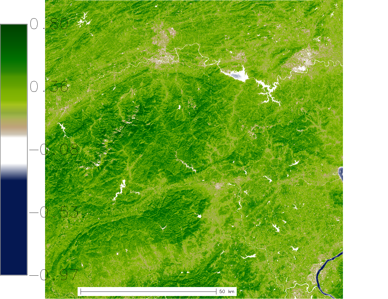
The following URLs point to the resulting PNG preview image and the NDVI GeoTiff file:
http://actinia.mundialis.de/api/v3/resource/demouser/resource_id-6b849585-576f-40b5-a514-34a7cf1f97ce/tmpsaeegg0q.png http://actinia.mundialis.de/api/v3/resource/demouser/resource_id-6b849585-576f-40b5-a514-34a7cf1f97ce/ndvi.tiff
The PNG preview should look like this: